 Dipsea Trail to Steep Ravine Matt Davis Loop | Photo by Joey Miller
Finally! After a grueling, but needed winter of all the rainy days, the sun has emerged and threatens to melt us all in its inexorable heat. So get the heck out of dodge and go explore the many incredible hiking destinations a stone’s throw in every direction of Sacramento.
Disclaimer! This article is meant to inspire trip ideas, but not to serve as your sole guide to adventure. Be sure to thoroughly research your trips in advance of departing, pack appropriately, find out whether you’ll have cell service and bring a buddy on every journey. Some great resources online include All Trails, Summit Post, ProTrails, The Outbound and Hikespeak.
Now read on, get inspired and plan some new adventures to see nature while it still exists.
Photo by Niki Kangas
Horsetail Falls to Ropi Lake
Desolation Wilderness | Twin Bridges, CA
Mileage: Supposedly about 6 miles, but depends if you lose the trail or detour.
Elevation Gain: 1,900 feet.
Difficulty Rating: Super hard, but worth it. A little sketchy at times. Some bouldering.
Distance from Sacramento: About 85 miles; an hour and a half with no traffic.
Lowdown: This is one of my favorite go-to hikes for Sierra summertime. You start at the Twin Bridges trailhead that also leads to Pyramid Peak (another great hike), just past Strawberry Lodge. There’s a parking lot and pit toilets, and you’ll have to pay a $5 daily use fee to park there. About a mile and a half in, you’ll make it to the falls and snake along the water as you ascend. There are many places to take a break and swim along the way. Honestly, although there’s a trail, I’ve never once managed to stay on it because it becomes difficult to follow. However, just fix your gaze on the top left side of the falls and adventure beyond the top of the falls. Follow the water, or trail if you’re lucky, to Ropi Lake, a breathtaking alpine swimming hole with views of Pyramid Peak. Grab dinner at Strawberry Lodge when you make it back, exhausted and happy.
Hidden Falls Trail | Photo by Niki Kangas
Hidden Falls Trail | Photo by Niki Kangas
Hidden Falls Trail
Hidden Falls Regional Park | Auburn, CA
Mileage: 3.2 easy miles.
Elevation Gain: 515 feet.
Difficulty Rating: Kid-friendly, easy and relaxing.
Distance from Sacramento: 38.9 miles from Sacramento; 52 minutes without traffic.
Lowdown: Hidden Falls is a perfect place to go if you only have a few hours or need a little nature without a lot of effort. Dogs are allowed on the trail if leashed, and because of its proximity to Sacramento and accessibility to all hiking levels, it tends to be highly trafficked. Besides hiking to the lovely waterfall, which is rushing this year with all the rain we’ve had, there are river spots for picnicking and swimming, verdant meadows with ancient oaks and shady groves to wander.
Bear Valley to Coast Camp via Arch Rock | Photo by Niki Kangas
Bear Valley to Coast Camp via Arch Rock
Point Reyes National Seashore | Point Reyes, CA
Mileage: 8.3 miles to camp, so this is better as an overnight backpacking trip rather than trying to do as a daytrip. If you only have a day to spend in Point Reyes, there are many other great hikes, including Bear Valley to Coast Camp via Mount Wittenberg.
Elevation Gain: 606 feet.
Difficulty Rating: Short bouts of uphill climbing, mostly rolling terrain. This hike is long for a day hike but great for a night under the stars.
Distance from Sacramento: 99 miles; about two hours without traffic, but there’s pretty much always some traffic, so plan on three hours.
Lowdown: This is an absolutely gorgeous hike that leads to tucked-away beaches and bluffs. It’s tough to get a campsite on a weekend at Coast Camp unless you plan way ahead, but play hooky and go on a weekday. It’s also rather hospitable all year long, not just summertime. Take Bear Valley Trail to Arch Rock, a unique geological feature that meets the sea, then cut north on Coast Trail and follow the bluffs past Sculptured Beach to Coast Camp. At Coast Camp, a monumental lone eucalyptus tree marks the sandy trail to the ocean. Hike-in campsites with grills, bear boxes, picnic tables and communal pit toilet restrooms are just behind the bluffs. Visit Cafe Reyes on the way home for awesome wood-fired pizza.
Table Mountain to Phantom Falls | Photo by Joey Miller
Table Mountain to Phantom Falls
North Table Mountain Ecological Reserve | Oroville, CA
Mileage: 6.5 chill miles.
Elevation Gain: 850 feet.
Difficulty Rating: Super easy and great for kids. You’ll be fine as long as you drop a pin at your car so you can find it again at day’s end, and use GPS since there’s really not a trail.
Distance from Sacramento: 75.5 miles; about an hour and a half if traffic-free.
Lowdown: A cross-country traverse, you’ll need to follow the fenceline to the right from the parking lot, through green meadows lit with wildflowers, to the top of the ravine. Cross the creeks, dip around another old fence (the only sketchy part) and you’ll spy the awesome waterfall spilling into the ravine through mossy, black basalt terraces. The day I went there in April, gray mist gave way to periodic hail and the flowers dazzled. Visit earlier in the summer while you wait for the snow to melt in the high Sierras.
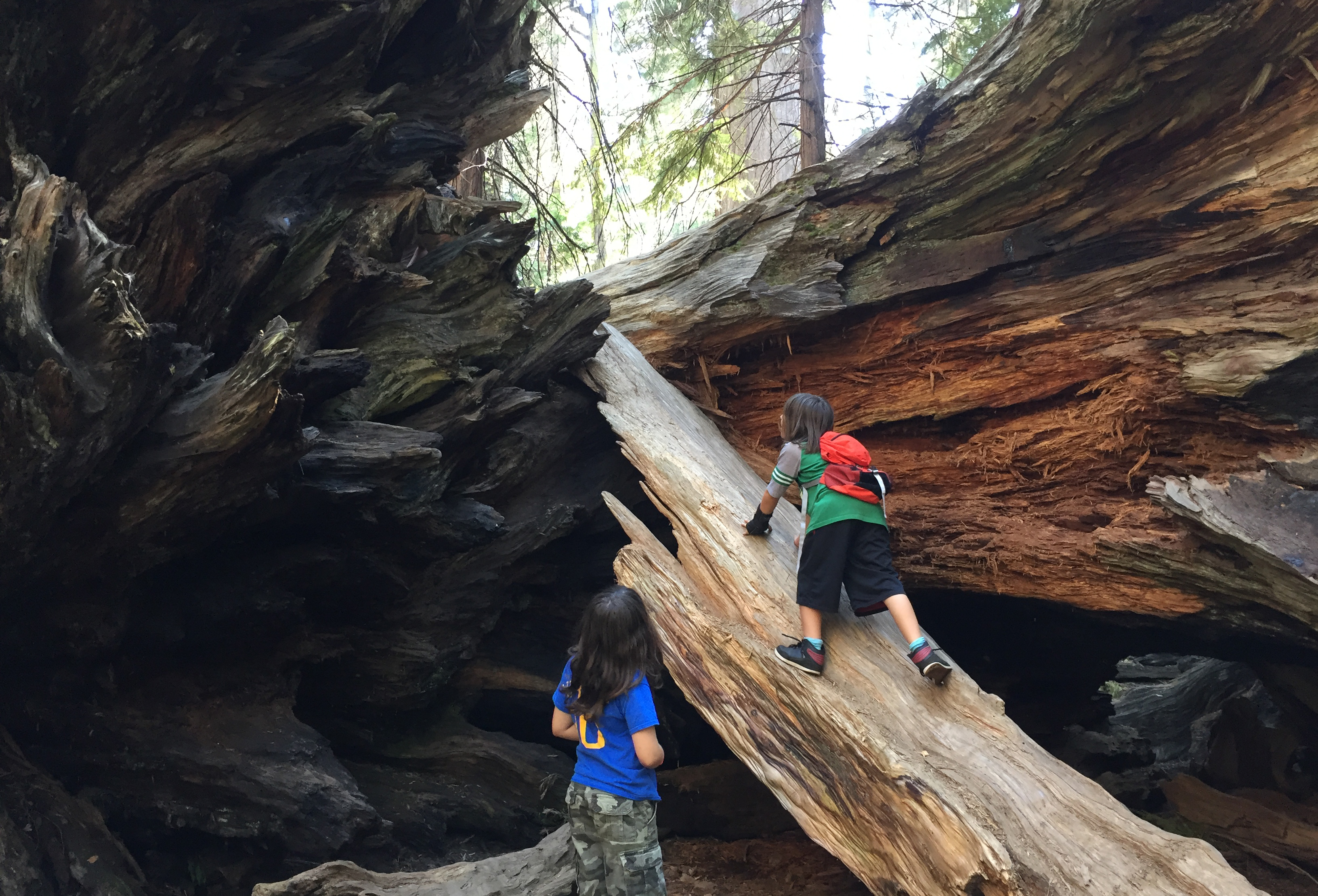
North Grove Loop | Photo by Niki Kangas
North Grove Loop
Calaveras Big Trees State Park | Arnold, CA
Mileage: 1.6 pretty flat, albeit jaw-dropping miles.
Elevation Gain: 70 feet. Piece of cake.
Difficulty Rating: Depends on how many fallen sequoias you climb. In all seriousness, though, easy as can be.
Distance from Sacramento: 100 miles; two hours without traffic.
Lowdown: Did you know there was an incredible sequoia grove with massive trees and a fern-covered forest floor just two hours from Sacramento? How did I just find out about this?! Nearly as impressive as Grant Grove in Sequoia National Park, this sequoia forest boasts trees surviving three millennia. You can camp right in North Grove, too! Impossibly, I last-minute snagged a site here on Memorial Day weekend. This is a wonderful place to take kids or spend a romantic weekend. Hit up Snowshoe Brewing Company on your way in or out.
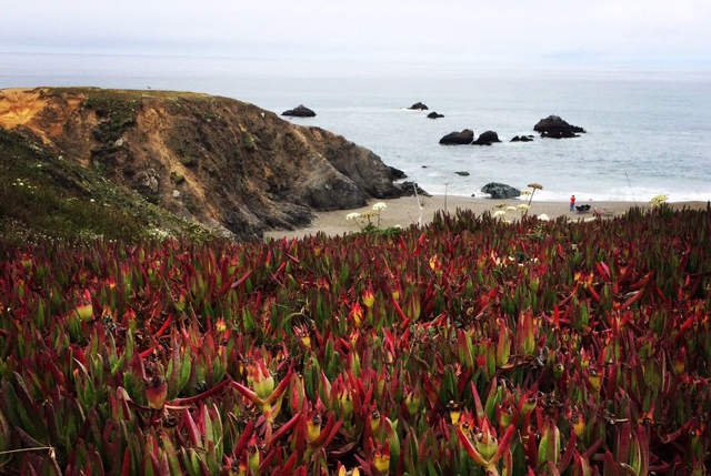
Dipsea Trail to Steep Ravine Matt Davis Loop | Photo by Joey Miller
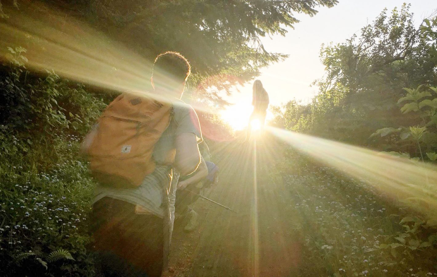
Dipsea Trail to Steep Ravine Matt Davis Loop
Mount Tamalpais State Park | Mill Valley, CA
Mileage: 6.8 miles of ever-changing terrain.
Elevation Gain: 1,820 feet. Some uphill for sure. Even a ladder in Steep Ravine to climb up a ledge.
Difficulty Rating: Moderate. My kids did it, as well as my friend’s 4-year-old, but it’s not for the feint of heart, either.
Distance from Sacramento: 94 miles, a little over an hour and a half with no traffic.
Lowdown: Start at the Pantoll Ranger Station, and enter the Matt Davis Loop Trail. Just beyond the affluent residential neighborhood, a lush forest awaits you. Ascend for a long-ass time until you come to Table Rock, a good spot to take a breather after going straight up! Along the well-maintained trail with wooden bridges and stone steps, it’ll soon open up into wide open grassy hills that then descend into Steep Ravine, a magical redwood forest trail that follows a rushing brook through old growth magnificence. Then, take the Dipsea Trail with sweeping ocean views and chaparral that eventually leads back to where you parked, or if you want to venture a bit further, to Stinson Beach for sunset.
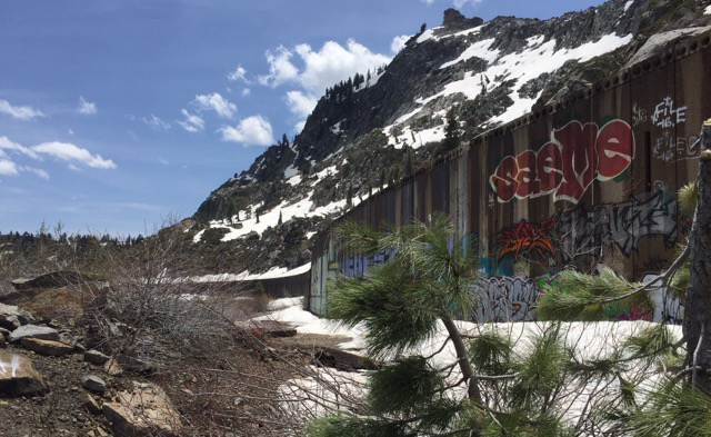
PCT to Donner | Photo by Niki Kangas
PCT to Donner Train Tunnels
Desolation Wilderness | Truckee, CA
Mileage: Up to you, but at least 2 miles.
Elevation Gain: 1259 feet, tops.
Difficulty Rating: Moderate. Uphill at first, then flat through the tunnels and downhill back. Some bouldering.
Distance from Sacramento: 92 miles; about an hour and a half with no traffic.
Lowdown: Park at Donner Pass and find the Pacific Crest Trail (PCT). The PCT leads from Canada to Mexico, and while I long to hike it end to end, for now, short sections of it have never let me down. On this section, just beyond your car, you’ll find grindstones and petroglyphs left behind by the Washoe people 1,500 to 4,000 years ago. The circa 1867 train tunnels are visible from the start of this hike, so just follow the trail up to the tunnels and go inside, where you’ll find rich history and a spectrum of graffiti ranging from awful to awesome. You might find some of my poor attempts at spraying inside! Walk through the tunnels as far as you’d like, or climb atop them and decide where you feel like pausing or turning back.

Comments